Walking in Western Provence & Languedoc-Roussillon
£14.00
76 long and short walks and 12 car tours
by John & Pat Underwood
25% off your next ebook when you sign up to our newsletter! Sign up here.
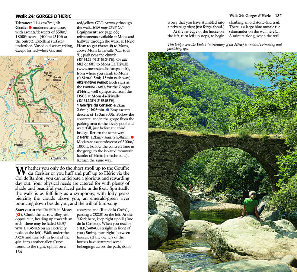
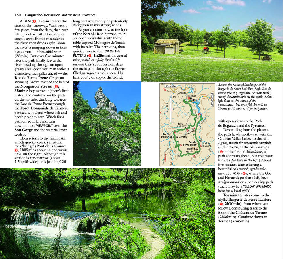
This new Fifth edition of our guidebook to walking in western Provence and Languedoc-Roussillon in France, features 76 long and short day walks in areas of outstanding natural beauty and historical interest. It has been thoroughly updated since the pandemic and is now presented in a wider format, so that no mapping is lost in the gutter.
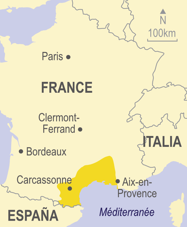
We cover an area beginning at Aix-en-Provence, heading west via the Lubéron and Mont Ventoux to the great Roman cities and the Pont du Gard. We travel north to the Ardèche, the Tarn and the Cirque de Navacelles and south through Hérault to Carcassonne and the Canal du Midi, crossing the Corbières and the Land of the Cathars to the foot of Canigou, holy mountain of the Pyrenees.
Routes of varying difficulty are featured, all of which are mapped in detail. Many of the hikes are circular, taking in the best of this region.
This guide also includes 12 car tours and two touring maps covering the area from the Pyrenees to the Italian border in the east.
When to go: Generally the best months for walking are March to June and September and October, but most of the walks described can be enjoyed throughout the winter months.
★★★★★ amazon review ‘We love these guides, especially as they have walks and car trips too. With car trips you can see more of an area more quickly . Lots of detail of interesting and unusual things to look out for in the countryside and with detail of places to stop for picnics outside with tables and benches. All the information we need and beautifully set out. Would recommend to anyone with a love of the countryside. Very informative.‘ Peggy Smith
Printed book: £16.99 / PDF ebook: £14.00

This guidebook to walking in Languedoc and Provence, half of a two-volume set, is intended for motorists who want to tour western Provence and Languedoc-Roussillon by car and enjoy some superb walks en route.
The drives have been described in such detail that there is no need to make constant reference to a map. The hikes selected – all set in areas of great natural beauty and historical interest – are those the authors believe offer the greatest sense of satisfaction for the effort involved.
These are not tough GR routes, but mostly circular treks suitable for moderately fit people.
The book is also ideal for those taking city breaks to places like Avignon, Carcassonne, Perpignan, Nîmes, Marseille, Montpellier with the budget airlines.
Excellent guide… The authors have captured the very essence of the countryside in a manner that is both personal and highly informative. I was impressed with the itineraries for exploring Provence by car… (Craig Bradshaw, Motoring and Leisure)
The first thing we do is check whether or not one of these valuable [Sunflower] guides is available. [We did] several tours from the Western Provence guide. (AH, Amazon)
We are regular users of the Landscape series and this one gives a comprehensive selection of walks, especially between Perpignan and Carcassonne. (LW, Amazon)
The book covers a lot of ground; good walking/touring bases are suggested at the start of each tour.
12 car tours, 76 long and short walks
184 pages + 2 touring maps (to cover all of Provence); 1:50,000 topo maps
5th ed, 2023; ISBN 978-1-85691-552-6; UK retail price £16.99 / USA retail price $22.00
Table of contents:
Preface 5
Bibliography 6
Picnicking 7
A country code for walkers and motorists 7
Touring 8
Car tour 1: NATURE TAMED BY INDUSTRY 11
A tour of 255km beginning at Aix-en-Provence and ending at Roussillon
Car tour 2: THE LUBERON 16
A circular tour of 166km beginning and ending at Roussillon
Car tour 3: MONT VENTOUX AND THE DENTELLES DE MONTMIRAIL 21
A tour of 182km beginning at Roussillon and ending at l’Isle-sur-la-Sorgue
Car tour 4: THE THREE-STAR ROUTE 27
A tour of 124km beginning at l’Isle-sur-la-Sorgue and ending at Pont du Gard
Car tour 5: ANTIQUITIES AND THE ALPILLES 31
A circular tour of 198km beginning and ending at Pont du Gard
Car tour 6: THE CAMARGUE AND ARLES 38
A circular tour of 278km beginning and ending at Pont du Gard
Car tour 7: LES GARRIGUES 42
A tour of 177km beginning at Pont du Gard and ending at Lodève
Car tour 8: CIRQUE DE NAVACELLES 46
A circular tour of 180km beginning and ending at Lodève
Car tour 9: CASTLES IN THE AIR 51
A tour of 184km beginning at Lodève and ending at Carcassonne
Car tour 10: MONTAGNE NOIRE 55
A circular tour of 201km beginning and ending at Carcassonne
Car tour 11: CORBIERES, LAND OF THE CATHARS 59
A circular tour of 195km beginning and ending at Carcassonne
Car tour 12: TOWARDS THE PYRENEES 64
A tour of 206km beginning at the Château de Queribus and ending at Couiza
Walking 68
Weather; What to take; Nuisances; Waymarking, grading, safety; Maps
WALKS
1 Colorado Provençal 72
2 From Roussillon to Gordes 75
3 Gordes and the Abbaye de Sénanque 78
4 Circuit around Buoux 81
5 Forêt des Cèdres 84
6 Dentelles de Montmirail 86
7 Pont du Gard 89
8 Gorges du Gardon 92
9 Circuit to the Cascades du Sautadet 95
10 Gorges de l’Ardèche 98
11 Barbentane and St-Michel-de-Frigolet 101
12 St-Rémy and Les Baux-de-Provence 104
13 Le Destet and Aureille 109
14 Tour des Opies 111
15 Digue à la Mer 113
16 Montcalmès, and a view over St-Guilhem-le-Désert 115
17 On the shoulders of Pic St-Loup 118
18 Source of the Vis 121
19 Montpellier-le-Vieux 124
20 Sentier de la Vallée du Tarn 126
21 Roc des Hourtous 128
22 Château de Malavieille and La Lieude 131
23 Cirque de Mourèze and Montagne de Liausson 134
24 Gorges d’Héric 136
25 Circuit above Olargues 140
26 Circuit above St-Pons 143
27 Gorges de l’Arnette and Hautpoul 146
28 Canal du Midi – Carcassonne to Trèbes 150
29 Minerve 153
30 Circuit above Lagrasse 156
31 Circuit above Termes 159
32 Peyrepertuse and the Fontaine de la Jacquette 162
33 Circuit below Peyrepertuse 164
34 Circuit to Quéribus 166
35 Circuit above Tuchan 169
36 The ‘Roman’ bridge at Bugarach 171
Glossary 173
Restaurants 175
Index 182
Touring map/transport information inside back cover
Aguilar, Château d’ 50
Aigue-Brun (river) 17
Aigues-Mortes 32, 33
Aix-en-Provence 10
Alet-les-Bains 51
Alpilles, Chaîne des 26, 29
Alsou, Gorges de l’ 48
Anduze 35, 36
Anglès 47
Aniane 37
Ansignan 52, 54
Antiques, Les see Glanum
Apt 10, 13, 17
Arboras 38
Ardèche, Gorges de l’ 76, 77
Arles 32, 34
Arnette (river) 44, 45, 47, 112, 113, 113, 114
Arpaillargues-et-Auriac 35
Atteuch 35
Aude (river) 54, 116-117
Aureille 84-85, 85, 86
Auribeau 17
Avignon 7, 23, 25, 26
Aymard 46
Banon 10, 13
Baou, Pic de 52, 54
Barbentane 78, 79
Baume, La 73, 73
Baux-de-Provence, Les 26, 28-29, 80-81, 82, 82
Beaucaire 27, 32, 34
Beaumes-de-Venise 21
Bédarieux 43
Bédoin 18, 21
Bedos, Col de 49
Bellegarde
Bergerie Neuve (near Puéchabon) 89, 91
Bonnieux 23, 25
Bories, Village des (Gordes) 15, 60-61, 64
Bouisset 47
Bouleternère 53
Brassac 110, 111
Brissac 38, 39
Bugarach 48, 51, 131, 132
Pech de 51, 131, 132
Buoux 17, 65, 66, 66
Fort de 17, 65, 66, 66
Cabesprine 47
Cabrières d’Avignon 24
Cadarache, Barrage de 10
Cadenet 14, 16
Cagalière, Roc de 120, 120, 121
Camargue 32-34, 87, 88, 88
Cambous, Village Préhistorique de 37
Canal du Midi 45, 46, 115, 116, 117, 116-117
Canal d’Oraison 11
Canal EDF 10, 16
Canarie, La 44
Canigou (mountain) 52
Capellière, La 33
Carbonnière, Tour (near Aigues-Mortes) 33
Carcassonne 42, 44, 45, 46, 47, 48, 51, 115, 116-117
Castellet 17
Castelnou 52
Catlar 53
Caudiès-de-Fenouillet 54
Caunes-Minervois 46
Causse-de-la-Selle 39
Causse du Larzac 40
Causse Méjean 98, 100
Causse de Sauveterre 98-99
Caylar, Le 38, 41
Cayron, Col du 18, 20
Cazilhac 39
Charleval 16
Châteauneuf 12
Citou 45, 46
Clamouse, Grotte de 38
Clamoux, Gorges de la 45, 47
Collias 72, 73
Colorado Provençal 13, 58, 59
Corbières 48-51, 131, 132
Corneilla-de-Conflent 53
Couiza 48, 51, 54
Courniou 46
Coustellet 15, 24
Couvertoirade, La 38, 41
Cros, Le 41
Cruis 12
Cruviers 35
Cubières-sur-Cinoble 50, 54
Cucugnan 50, 126-127, 128
Cuxac-Cabardès 44
Dabisse 11
Davejean 49
Défilé de Pierre-Lys 54
Demoiselles, Grotte des 35, 37
Dentelles de Montmirail 18, 20, 68, 69, 69
Destet, Le 26, 29, 84-85, 85
Devèze, Grotte de la 44, 46
Deyme 65, 66
Digue à la Mer 32, 34, 87, 88, 88
Duilhac-sous-Peyrepertuse 48, 50, 125, 126-127
Durance (river) 10, 16
Durfort, Château de 49
Escale, L’ 11
Espinouse, Monts de l’ 44, 46, 107, 108
Estagel 52
Eygalières 26, 29
Fangassier, Etang du 87, 88
Félines 49
Fillols 53
Flassan 22
Fontaine de la Jacquette (Peyrepertuse) 124, 126-127
Fontaine-de-Vaucluse 22, 23
Fontvielle (Le Moulin de Daudet) 28, 30
Força Réal 52
Forêt des Cèdres (Petit Lubéron) 14, 17, 67
Fosse, La 32
Galabert, Etang de 87, 88, 88
Galamus, Gorges de 48, 50, 52, 54
Ganges 36
Gardon (river) 27, 35, 36, 70, 71, 72, 73, 73
Garrigues 35
Gignac 37
Gigondas 18, 20, 68, 69
Glanum 26, 27, 30, 82
Gordes 14, 15, 60-61, 61, 62, 63
Gorniès 39
Hauterives 97, 98
Hautpoul 112, 113, 114
Hérault (river) 37, 38, 39
Hérépian 43
Héric, Gorges d’ 42, 43, 105, 107
Hourtous, Roc des 98-99, 98, 100
Hortus (mountain) 37, 93
Isle-sur-la-Sorgue, l’ 18, 22, 23
Jaur (river) 44, 108
Labastide-Rouarioux 44
Lacoste 24
Lafare 21
Lagrasse 48, 120, 120, 121
Largue, Le 13
Laroque 35, 37
Lespinassière 46
Leuc 51
Liausson (mountain) 43, 103, 104, 104
Lieude, La 42, 101, 102
Limoux 48, 51
Lodève 35, 37, 38, 41, 42
Lourmarin 16
Lubéron (mountain) 4-5, 10, 14-15, 16, 17, 24, 62
Lure, Montagne de 10, 12
Madeleine, La 36
Madières 1, 39, 41
Maisons 50
Malaucène 20, 21
Malavieille 42, 101, 102
Château de 42, 101, 102
Malène, La 97, 98, 99, 100
Mallefougasse 12
Marquixanes 53
Martys, Les 44
Mas-Blanc-des-Alpilles 28
Mas-de-Pontèves 34
Mas-des-Iscles 32
Maury 52
Grau de 48, 50, 52
Maussanne-les-Alpilles 28
Mazamet 42, 44, 45, 47, 112, 113
Mazan 21
Mées, Les 11
Rochers des 10, 11, 13
Ménerbes 24
Millas 52
Minerve 46, 118, 119, 119
Monieux 22
Monoblet 36
Mons-la-Trivalle 42, 43, 105, 107
Montagne Noire 44, 46
Montagnette, La 30
Montcalm 32, 33
Montcalmès 35, 89, 90
Montferrand, Château de 37, 93, 93
Montmajour, Abbaye de 29
Montpellier-le-Vieux 2, 41, 96, 96
Montpeyroux 38
Monze 48
Mouline, La (near Octon) 42, 43
Mourèze (village) 43, 103, 104, 104
Cirque de 42, 43, 103, 104, 104
Murs 4-5, 14
Navacelles, Cirque de (and village) 8-9, 38, 40-41, 94, 95
Nesque, Gorges de la 18, 22
Nîmes 26, 27
Nore, Pic de 44, 45, 47
Notre-Dame-de-Faste 129, 130
Notre-Dame-de-Londres 37
Notre-Dame-de-Lure 12
Notre-Dame-du-Groseau 18, 20
Octon 42
Olargues 42, 43, 44, 108, 109
Opies, Les 84-85, 85, 86
Oppède-le-Vieux 23, 24, 25
Orange 26
Orb (river) 43
Orbieu (river) 48, 51
Padern 50
Papeterie, La 39
Paradis, Le 33
Paulons, Les 12
Peipin 11
Peiroou, Barrage des 82, 82
Pernes-les-Fontaines 22
Peyrepertuse, Château de 49, 50, 124, 125, 126-127
Pézilla-de-Conflent 54
Piémanson, Plage de 32, 34
Plo de la Bise, Belvédère du (near Mazamet) 44
Pont-de-Gau Bird Sanctuary 33
Pont du Gard 23, 25, 26, 31, 32, 34, 35, 36, 70, 71, cover
Pont Julien (near Apt) 23, 25
Pont-Mirabeau (near Aix) 10
Pont St-Nicolas 27
Poujol-sur-Orb, Le 43
Pradelles-Cabardes 47
Pradelles-en-Val 48
Prades 53
Premian 44
Puéchabon 35, 37, 89
Puilaurens 54
Puivert, Château de 54
Quéribus, Château de 48, 50, 52, 126-127, 128
Quillan 52, 54
Ranc Pointu (belvédère) 76
Raviège, Lac de la 45, 47
Régalon, Gorges du 16
Remoulins 25, 31
Rennes-les-Bains 51
Rhône (river) 7, 27
Ria 53
Rialet, Le 47
Rieisse 98, 100
Riols 44
Robion 15
Rochefort-du-Gard 31
Rogues 40
Roque-sur-Cèze, La 74, 75
Roquemaure 31
Rouffiac-des-Corbières 49, 50, 126-127
Roussillon 10, 13, 14, 17, 18, 22, 60, 61, 60-61
Route des Crêtes 16
Sablet 20
Saignon 14, 17
St-Amans-Soult 44
St-André-de-Sangonis 37
St-Antoine-de-Galamus 51
St-Bauzille-de-Putois 37
St-Chély 97
St-Donat (chapel near Sisteron) 12
St-Etienne-d’Issensac 38, 39
St-Etienne-les-Orgues 10, 11
St-Felix-de-Pallières 36
St-Gilles 32
St-Guilhem-le-Désert 38, 39, 89, 91
St-Hilaire 51
St-Hippolyte-du-Fort 36
St-Jean-de-Fos 38
St-Jean-de-Sault 19
St-Julien (priory near Olargues) 109
St-Loup, Pic 35, 37, 92, 93, 93
St-Martin (chapel near Sisteron) 11
St-Martin-de-Londres 35, 37
St-Martin-des-Oeufs (chapel near Olargues) 108, 109
St-Martin-des-Puits 49
St-Mathieu-de-Tréviers 92, 93
St-Maurice-Navacelles 40, 41
St-Michel-de-Cuxa, Abbaye 52, 53
St-Michel-de-Frigolet 30, 78, 79, 79
St-Michel-de-Grandmont, Prieuré (near Lodève) 38
St-Michel-de-Llotes 53
St-Paul-de-Fenouillet 52, 54
St-Pierre-de-la-Fage 41
St-Pierre-de-Rhèdes (chapel near Lamalou) 43
St-Pierre-des-Champs 49
St-Pons-de-Thomières 42, 44, 45, 46, 110, 111, 111
St-Privat 38
St-Rémy-de-Provence 26, 27, 30, 80, 82
St-Saturnin-lès-Apt 18
St-Sixte (chapel near Eygalières) 26, 29, 30-31
St-Sylvestre-des-Brousses (chapel near Puéchabon) 89, 90, 91
St-Symphorien (priory near Bonnieux) 17, 66
Ste-Vérédème (chapel near Collias) 73, 73
Stes-Maries-de-la-Mer 32, 33
Salagou, Lac du 42, 104
Salasc 43
Salces, Les 38
Salin-de-Giraud 34
Sambuc, Le 34
Sanilhac 73
Sault 18, 19, 22
Sautadet, Cascades du 74, 75
Sauveterre 31
Sauze 76
Séguin (near Buoux) 65, 66
Ségure 50, 129, 130
Séguret 20
Sénanque 60-61, 64
Abbaye de 14, 60-61, 63, 64
Serre, Roc du 98, 100
Silvacane, Abbaye de 14, 16
Simiane-la-Rotonde 10, 13
Sisteron 10, 11
Sorgue (river) 22, 23
Soulatge 50
Sournia 54
Suzadou, Roc 45, 46
Suzette 21
Tantajo, Pic de 43
Tarascon 26, 27
Tarn, Gorges du 41, 97, 98-99, 98, 100
Taurinya 53
Termes (village and château) 48, 49, 51, 122, 123, 123
Thor, Le 25
Thouzon, Grotte de 25
Trèbes 47, 48, 115, 116-117
Tuchan 50, 129
Uzès 35
Vaccarès, Etang de 33
Vacquerie, La 41
Vacqueyras 21
Vaison-la-Romaine 18, 20
Val d’Enfer 80-81, 82
Vaucluse, Plateau de 18, 20-21
Venasque 14
Forêt de 14
Ventoux, Mont 18, 19, 20-21
Verdouble (river) 48, 50, 125, 126-127
Vers-Pont-du-Gard 70, 71
Vialais (river) 105, 106, 107
Vidauque, Combe de 14, 15
Villalier 46, 47
Villefranche-de-Conflent 52, 53
Villegly 46, 47
Villeneuve (Camargue) 33
Villeneuve-lès-Avignon 26, 31
Villeneuve-Minervois 47
Villes-sur-Auzon 22
Vinça, Barrage de 53
Vintrou, Le 47
Viols-le-Fort 37
Vis (river) 38, 39, 94, 95
Volonne 11
Yés, Les 47
Western Provence, 5th edition (2023); updated 09/05/24
Updates for walks and car tours (drives) in western Provence given below supplement those provided in the guidebook. It is vital that this Update is read in conjunction with the text of the book, but note that the Update applies only to the edition stated and not to any earlier editions. (If you have an older edition of this book you can “upgrade” to the latest edition at half price.)
Information has been forwarded to us by users of the book, and Sunflower Books offers the data in good faith but cannot be held responsible for any misleading or inaccurate content in the Update. Unless indicated otherwise, what appears here has not been verified by the author or publisher, so please allow due caution when new or amended routes are suggested. Each piece of information is dated; bear in mind that some of the older observations may have since been overtaken by events or further changes.
If, during your holiday, you are using the current edition of the guide and are able to provide any additional updating to add to this page, we will be pleased to hear from you.
Please send information, preferably by e-mail, to info@sunflowerbooks.co.uk.
Walk 7: The railway tracks at the start and near the end of the walk have been turned into a cycle path. There is no longer a ‘barrage of signposts’ at waypoint 3, just a ‘Pont Roupt’ sign, indicating that the Post du Gard is 0,9km ahead. As of 5/24 there was no signpost opposite indicating the path through the garrigues (the return route). Having viewed the Rive Droite Panorama, and crossed to the left bank, the sign doesn’t mention the GR6/63 or PR41; it now indicates the left bank viewpoint, and you still go straight ahead up steps; nearing the top they are wooden. At the top of the steps there is a wooden platform. If you are feeling peckish in Vers and nowhere is open, go to the bakery in the Place du Marché on the road to Castillon, where you can get something savoury or sweet to eat and a drink. (Authors, 5/24)
Walk 11: This walk suffered terrible forest fires in summer 2022, and the area south of the Draille du Mas de la Dame is a mass of tracks, firebreaks and burnt-out scrub. We suggest doing the walk to the draille, then going direct to waypoint 7. So unless you have time on your hands, this is a walk to miss. (Authors, 5/24)
Walk 13: The moto-cross circuit has been closed since 2010! But no one cleared it. In 2023 its was decided to clean it up but this will take a lot of time, since they’ve identified no fewer than 1400 tires and other rubbish! The ‘cultivated fields’ before and after the 2h30min point are now more olive groves. (Authors, 5/24)
GPS files for use with Walking in western Provence and Languedoc-Roussillon:
Download GPS files for western Provence and Languedoc-Roussillon.
iPhone users need a free or paid app to open the zip file and see the files stored inside it. There are a variety of apps that can open zip files on the iPhone, but Zip Viewer is one of the easiest to use – and it is free.

